FRANK GOHLKE: COORDINATES AND THE LINES BETWEEN

by Kirsten Rian

Published on 05/26/ 2016

In his essay Starting from Loss, the foreword to the book Kentucky’s Natural Heritage, Wendell Berry writes, “When we consider all that we have lost, ruined, or squandered since our European forebears came to live in this place only 235 years ago, we have to conclude that, as a people, we Kentuckians have had only a vague and feckless sense of where we are.”

Further into the piece he continues, “No other book that I have read has helped me so much to think about the land of Kentucky, of the reciprocity of influence and the sharing of fate between the land and ourselves.”

Loss, no idea where we are, reciprocity and sharing of fate. I write a lot about land and geography because I’m humbled by how it holds us and marks the paths we make as we shuffle along throughout our lives, bending grass and divoting dust. Loss has pocked recent years, a death in the immediate family, head tumors and other logic-defying happenings. But each newly turned over day, I look out the window from my kitchen or upstairs office, and the trees are still there, the sky blackens each night, the morning horizon is clearly visible and still a straight line. This is what I know. The landscape is all I know.

“This is what I know. The landscape is all I know.”

Gohlke looks at the world, then translates in his photographs. I remember hanging a very large print of his, way back when I was running a photo nonprofit, I remember tangled branches, and fragments of sky charming the corners of the frame. And bits and pieces of those memories, blur forward and mingle with the thoughts Gohlke shares in his answers to my questions, composing a continuing fugue perhaps of the land’s and everyone’s stories playing themselves out on the staff of latitude lines along with, as he writes, sticks, and twigs, and mysteries.

Gohlke tells me, “We can acknowledge that the world contains mysteries without indulging in mystification. A photograph can turn a hunch or an intuition into an apparent fact without leaching it of its mystery. Good trick.”

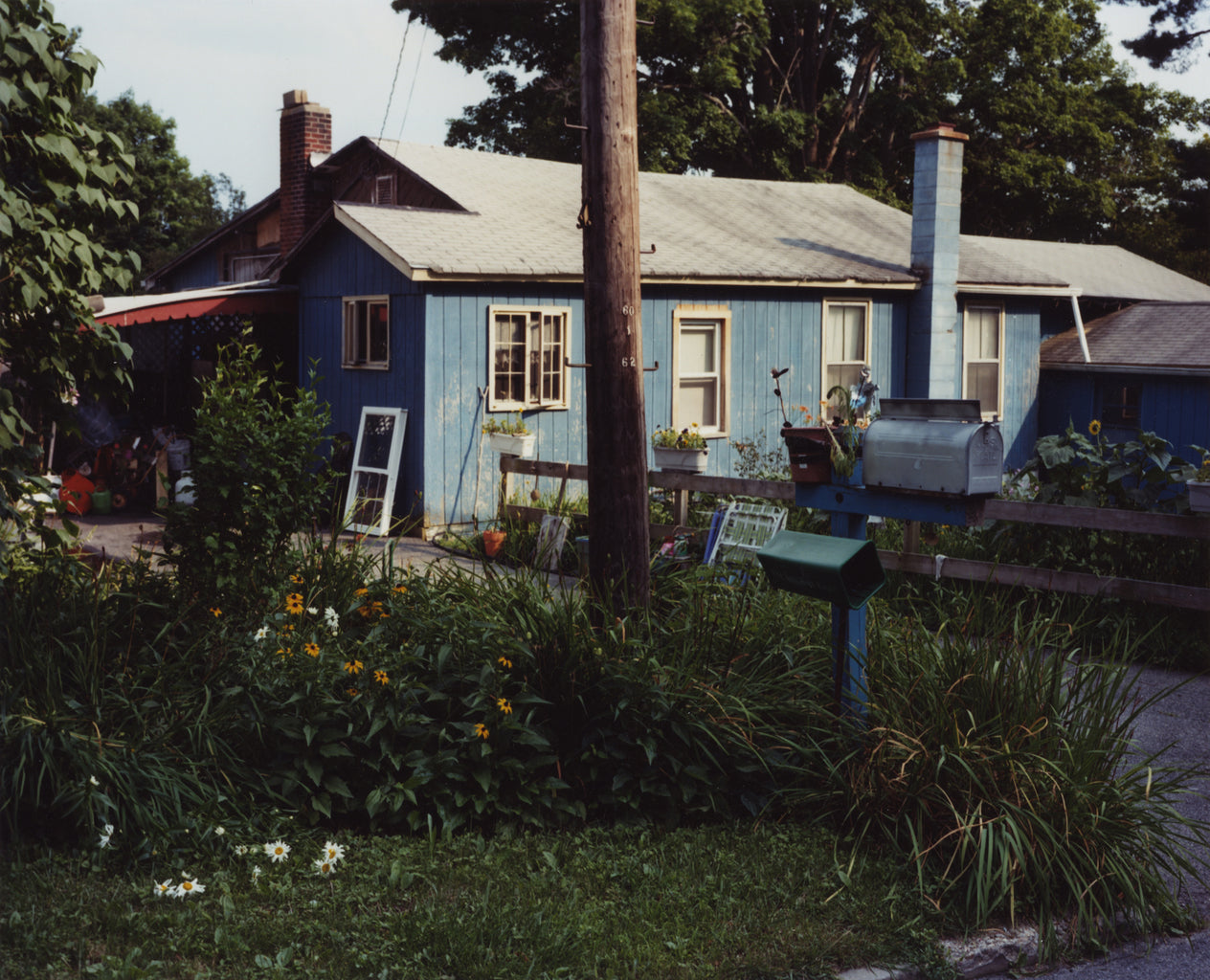
From 2002-2009, Gohlke and poet and landscape historian Herb Gottfried, explored a one-mile wide and 165 miles long strip of land, the geographic coordinates of 42.30N and 42.31N. The interlacing literal and visual imagery document a time and place, a cultural and environmental landscape, and also the footfalls of two friends. It is images from this project that you see here.

“I also realized, this was a perfect opportunity to do something I hadn’t done in a long time: just wander around taking pictures of whatever interested me,” Gohlke tells me of his collaborative project with Gottfried.

“Herb noticed that his house in Ithaca, New York was located at 42.30 N and that the line went through Massachusetts, not far from my home in Southborough. He proposed we follow that line from Marblehead, Massachusetts where it enters the Atlantic to his home in Ithaca. In other words, it was arbitrary.”

42º30” North is land that stretches about 1 mile wide by 165 miles long. It can be measured, coordinated, walked, driven. Looked at. Every line is exact and arbitrary at the same time.

“I am giving up the landmarks by which I might be taking my bearings.”
Antoine de Saint-Exupéry, pilot.

“Anything that interested me in the area between 42.30N and 42.31N was a potential subject,” Gohlke says. “I had a very loose notion that I was creating a synecdochal portrait of Massachusetts as a whole, but I was also, and perhaps mainly, interested in the way an idea affects the way we look at a rather random group of photographs. Well, sort of. This is where it gets complicated. On the one hand the project was an excuse for a series of road trips, one of my favorite photographic activities, where the generative idea gave me a frame in which I could photograph anything I felt would make an interesting picture.

At the same time I could not prevent the idea that I might be creating some kind of inventory from creeping into my decisions, in which case the issues of statistical accuracy (just how rocky is Massachusetts anyway?), representativeness (how eccentric are my choices of what to photograph?) and (gasp) truth to my experience became more important than I had expected they would. Where did my sense of responsibility come from? The landscape, a totally artificial construct to which it is ridiculous to attribute agency of any kind? The history of landscape photography? My Calvinist fore bearers? And what does it matter? You get the drift.

“The fact is that this body of work is very troublesome to anyone who likes a neat package, but it’s also too self-evidently in the landscape mode for its disparateness to become the ruling idea. The bottom line is that I really like all of these pictures individually. The way they are ordered is intended to short-circuit the tendency to read the geographical element, with its built in linear dynamic, into each picture, as if they were all just stops on a railroad journey from east to west across Massachusetts (or vice-versa). The latitude provides some minimal coherence, but really it’s about wandering around responding to what I see. The fact that I happen to be wandering in a straight line is incidental.”

“What begins as undifferentiated space becomes place as we get to know it better and endow it with value…The ideas ‘space’ and ‘place’ require each other for definition. From the security and stability of place we are aware of the openness, freedom, and threat of space, and vice versa. Furthermore, if we think of space as that which allows movement, then place is pause; each pause in movement makes it possible for location to be transformed into place.” Yi-Fu Tuan, from Space and Time.

“It may not be a coincidence that our vision is adjusted to see the sky as a pure hue. We have evolved to fit in with our environment; and the ability to separate natural colours most clearly is probably a survival advantage.” Philip Gibbs, from The Physics and Relativity FAQ.

“Isn’t it odd that one can do a thing and live with it for so many years and not know what it is? And then, with an ordering of photographs and a paragraph of prose, know. And know one knows,” Gohlke says.

I ask Frank about something he wrote years ago in 1986: “These photographs, taken together, comprise a story, but only kind of a story,” and I ask him about the story, the kind of or otherwise, of the Massachusetts work.

“These photographs, taken together, comprise a story, but only kind of a story.”

He replies, “If I sequence the pictures from west to east or east to west, that’s one kind of story, and a fairly simple, linear one. I only have to include the end points and put them in correct order and it’s complete. If I group them according to categories of subject matter, such as Agriculture or Architecture or Development or Water, that’s a different story; such a procedure creates an expectation of comprehensiveness. Once the viewer has understood the model, s/he is justified in complaining ‘What about Commerce, Animals, Recreation, Historical Sites, Forests’ and so on. Don’t want that: too simple, necessarily incomplete and not the point of what I dimly understood myself to be doing. I’m sure I could think of other schemes I wouldn’t want, but what’s the point of that?

“The risk of what I have done is incoherence, but that’s where the latitude comes in: a long row of hooks to hang pictures from. Like a coat hook, it doesn’t matter what you hang from it. There’s no way to say ‘That doesn’t belong there.’ You can say it, but you’re just expressing a preference that has no persuasive force. If it’s my coat hook, and I say it belongs, it belongs. And the story? Whatever you can make up out of the fragments I’ve provided; if the sequence works, then it implies no bias toward any of the infinite number of stories you can concoct with the materials at hand. If you detect a bias, I disown it. So there. The only rule is that you don’t falsify what’s in the photographs. If there’s a dog and you need a cat to make your story work, that’s too bad. It’s a dog; make it work or start over.”

“Although it has real-world consequences, the coordinate system is a fiction, an abstraction, the projection of the Enlightenment’s mania for rationalizing everything. This is not news, but the materially insubstantial nature and the absence of any compelling reason for that line over any other meant that I was free of responsibility to any pre-existing geographical entity. If there was any landscape to be characterized, it was a landscape Herb and I were creating in our travels and work along the line,” Gohlke shares.

“…When I think about the last photograph in the sequence, I am confronted with a question I can’t answer: why does a haphazard arrangement of sticks and twigs, seen from a particular vantage point, seem so important to me, seem to mean something not accounted for by what is depicted, make me so happy? Whether it does that for anyone else is another question, but my vote on this is finally the only one that counts,” says Gohlke.

An opeidoscope illustrates sound with rays of light, by reflecting from a mirror and projecting the vibratory motion of singing or speaking.
A fiberscope examines inaccessible areas.
A serimeter tests the quality of silk.
With a topophone one could determine the direction and distance of a fog horn.
Selenoscopes view the moon.
Xathometers measure the color of sea or lake water.
A goniometer measures the angles between faces.
Sometimes gratitude is in geometry.
With a helioscope one could look at the sun.
If you haven’t yet discovered Gohlke’s particularly resonant way of seeing, find his photos and look at them. Go back–over 40 years’ worth of images–look at the destinations of idea, noticing, feeling, interchanging interpretation and land. See all this, find it in his photographs. Then go look at the sky. Or the side of the building over there. Or that photo of Gohlke’s, the one with the shadow made by a line of gas pumps standing like sentinels in the sun.